 |
 |
 |
||
Stokes Valley History Part Four
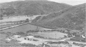
Stokes Valley RoadsDuring the early days of the development of the Hutt Valley, roads consisted of tracks six feet wide cut through the bush. Mr Samuel Brees, the second Surveyor-General to the New Zealand Company, gives an account of a surveyor's encampment as follows: "...narrow alleys, technically termed lines, are cut straight through the forest and in various directions for the purposes of the survey. Some of those lines form the skeletons of future roads, and extend a distance of many miles into the country, forming for a time the only available means of transit." Before the Taita Gorge road was formed in 1847 the main road from Lower Hutt ascended the hills at the southern end of the gorge, followed along the top of the hills, and came down at the entrance to Stokes Valley, The road was continued in a semi- circular sweep, crossed the Stokes Valley creek, and climbed the hills again near the entrance to the upper gorge, to descend near the Silverstream Hospital site. You may still find remnants of this track today. In 1846 Mr William Judd had the contract for building the road through the Taita Gorge. Owing to the nature of the hillside this was a long and hazardous undertaking. Slips were a continual cause for anxiety and danger, and on occasions road making tools were lost in the falls of earth. The following letter written 150 years ago is copied from the original in the archives of the Lands and Survey Department. It is possible that some of the signatories lived at Haywards.
The Main Road in Stokes Valley was formed in 1874, the contractor being George Southee. The road now known as Glen Road was surveyed in 1842 at the same time as the Main Road, hut was not formed until many years later. After 1900 this was commonly known as Luff's Road. Some of the men who assisted in building the road lived in mud huts in the district. It is possible that these huts were built by people inhabiting the Valley before the grant of properties. Before 1921 the Main Road terminated at a gateway approximately halfway between Kamahi and Raukawa Roads, although it bad been surveyed to within 200 yards of its present terminus. By 1928 the following roads in S D Thomson's sub- divisions were formed and metalled: Kairimu, Manuka, Kamahi, Raukawa, and the remainder of the Main Road. Extensions of Manuka and Raukawa Roads were not completed until 1937.Glen Road was metalled in 1930 and Korau Road formed and metalled in the same year. With the subdivision of the Sunshine Estate, Kennedy, Montgomery, and Milford Roads were formed and came under control of the County Council in 1944. A further subdivision of the Thomson Estate brought about the formation of Kopara, Kereru, Tawhai, Pokapa, and Maru Roads, which were banded over to the County in 1946. Hawthorn Crescent was named after Mr. H J Hawthorn, who cut up his property in 1945. Morrison Avenue was completed in 1949. The first part of Rawhiti Place was completed by 1950 and the bridge over the stream and an extension of the road were completed in 1954. The tar sealing of that portion of the road from the Taita Gorge corner to Mitchell's corner was completed in 1928, but Main Road was not sealed until 1940. In 1921 the contract was let to Messrs. George Parker and W Graham to clear the gorse from the side of the Main Road, which up until that time consisted of metalled wheel tracks with the gorse growing up to the road edge and practically meeting overhead. The contract involved clearing the Main Road from Glen Road to Kamahi Road. At places, particularly near Speldhurst corner, the gorse bushes were huge, some of the trunks being six inches in diameter. When asked for his most vivid recollection of his early days in Stokes Valley, George Parker grimly replied "Gorse!" |
||||
| Policies | Advertising | Stonefish | ||||